


Resource Protection Area and Resource Management Area FAQ's

For questions about the CBPA, RPA, or RMA please contact the Environmental planner at 757-357-9114 or by email at sbeussink@iwus.net
WHAT CAN PROPERTY OWNERS DO IN THE RPA?
To begin the Application progress click here .
Existing structures in the RPA including lawns, gardens and other maintained landscaping, may remain and be maintained as they existed when the RPA was designated on the property (prior to 1989) but may not be expanded upon unless a encroachment or exception is granted.
Permitted Encroachments into the Buffer Area
- When the application of the buffer area would result in the loss of a buildable area on a lot or parcel recorded prior to October 1, 1989, encroachments into the buffer area may be allowed through an administrative process, in accordance with sections 4003 and 5000 and the following criteria:
- Encroachments into the buffer area shall be the minimum necessary to achieve a reasonable buildable area for a principal structure and necessary utilities;
- Where practicable, a vegetated area that will maximize water quality protection, mitigate the effects of the buffer encroachment, and is equal to the area of encroachment into the buffer area shall be established elsewhere on the lot or parcel; and
- The encroachment may not extend into the seaward fifty (50) feet of the buffer area.
- When the application of the buffer area would result in the loss of a buildable area on a lot or parcel recorded between October 1, 1989, and March 1, 2002, encroachments into the buffer area may be allowed through an administrative process
Permitted Activities
NOTE: All permitted activities require County approval before commencing.
- Water-dependent facilities, such as docks and piers
- Commercial and residential piers or docks, and the access paths or walkways to these facilities are permitted by the County. It should be noted that the construction of private or public piers must be evaluated by the following regulatory agencies: The Army Corps of Engineers (USACE), The Virginia Marine Resources Commission (VMRC), and the Isle of Wight County's Wetlands Board. The Department of Community Development can assist you in obtaining information regarding this application procedure. For more information on how to start the process click here
- Prior to obtaining a building permit, the pier or dock or other shoreline activity receives approval for development in the CBPA. A copy of approvals of the various boards and commissions must be delivered to the Department of Community Development prior to approval for development in the CBPA.
- A water- dependent Water Quality Impact Assessment must also be completed and can be found here.
- Water wells, boardwalks, trails, pathways & public utility structures
- Pathways shall not exceed five (5) feet in width and shall be paved with a permeable material
- Selectively removing trees, for reasonable sight lines & vistas or pedestrian walkways (created using natural materials)
- The establishment of sight lines, vistas and access paths are permitted in the RPA 100- foot buffer. However, a property owner should contact the Count Planning Staff to discuss the appropriate ways of doing sight lines, vistas and access paths.
- The Chesapeake Bay Preservation Area Ordinance (CBPO) preferred sight line filters the view through vegetation and retains existing trees, shrubs and ground cover. It can be achieved by removing limbs and trimming branches of trees as well as pruning shrubs. Vistas can be created where the buffer is thin and as long as existing trees, shrubs and ground cover remain on either side of the framed view and on the slopes to the buffer protected feature.
- Access paths, materials to be used, and vegetation to be removed should be identified on a plan submitted for review and approval by the Department of Community Development.
- More Guidance can be found here.
- Removing dead or dying vegetation
- Dead, diseased, or dying trees or shrubbery and noxious weeds (such as Johnson grass, kudzu and multiflora rose) may be removed and thinning of trees allowed as permitted by the zoning administrator pursuant to sound horticultural practices.
- More Guidance can be found here.
Resource Protection Area (RPA) Modification Request Application can be found here .
CAN VEGETATION BE REMOVED?
-
To provide reasonable sight lines, general wood lot management and habitat management. Any vegetation removed must be replaced with vegetation that provides equivalent water quality benefits and environmental protection. For more information please see the Sightline Guidance.
-
To create access paths. Such paths and appurtenances cannot cause erosion.
-
To remove dead, dying or diseased trees and shrubs, and to remove noxious weeds or invasive exotic plants. Any vegetation removed may require replacement vegetation equally effective in providing water quality benefits and environmental protection. Please see Guidance for Dead, Diseased, or Dying Vegetation
-
To provide for shoreline erosion control. Buffer must be reestablished with native, woody vegetation. Please contact the County for more information.
To begin the Application progress click here.
Additional information about riparian buffers can be found here.
Native plant species for replacement can be found here.
WHAT ACTIVITES ARE NOT ALLOWED IN THE RPA?
- Development is not permitted when there is sufficient buildable area outside the 100-foot buffer or if the property was subdivided after the Chesapeake Bay Preservation Ordinance (CBPO) or a subsequent amendment was adopted.
- Accessory structures like sheds, gazebos, pools, or detached garages may not be located within the 100-foot buffer without the approval of an exception via a public hearing with associated fees. Form to begin the process.
- Clear-cutting of vegetation is not permitted nor is the removal of native vegetation to create lawns.
- Application of pesticide and fertilizer is strongly discouraged.
ARE FENCES ALLOWED IN THE RPA?
-
Fences should be designed so that they do not inhibit or alter surface flow (i.e., water must be able to flow under and through the fence unimpeded).
-
Vegetation may only be removed to provide for the actual placement of the fence.
-
Where vegetation is removed, it must be replaced with other native vegetation that is equally effective in retarding runoff, preventing erosion and filtering stormwater runoff.
-
Fences should be located to avoid the removal of trees.
ARE DECKS ALLOWED IN THE RPA?
SHORELINE EROSION CONTROL PROJECTS i.e. RIPRAP, BULKHEADS, AND LIVING SHORELINES, ETC..
As of July 1, 2020, in the Commonwealth of Virginia, living shorelines are required unless the best available science shows that would be not suitable on the site.
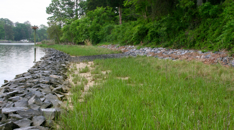 Photo credit: https://vaswcd.org/living-shorelines and https://www.vims.edu/features/research/living-shorelines.php
The Chesapeake Bay Foundation six step guide is a great place to start.
The Chesapeake Bay Trust defines "Living Shorelines" as shoreline stabilization techniques that use natural habitat elements to protect shorelines from erosion while also providing critical habitat for Chesapeake Bay wildlife. The benefits of living shorelines include:
- stabilization of the shoreline
- protection of surrounding riparian and inter-tidal environment
- improvement of water quality via filtration of upland run-off
- creation of habitat for aquatic and terrestrial species
It is the Commonwealth’s policy that living shoreline practices are the preferred alternatives where possible. The definition of a living shoreline means a shoreline management practice that:
- provides erosion control and water quality benefits;
- protects, restores or enhances natural shoreline habitat; and
- maintains coastal processes through the strategic placement of plants, stone, sand fill, and other structural and organic materials. [Code of Virginia §28.2-104.1]
The Virginia Institute of Marine Sciences (VIMS) is one of the leaders in designing and implementing living shorelines on public and private lands throughout the mid-Atlantic region. If you are considering a living shoreline on your property, visit the VIMS Shoreline Studies Program to download design guidance and the VIMS Center for Coastal Resources Management has a wealth of information on building criteria, permit requirements, planting considerations, demonstration sites, and other useful information.
- Be necessary (i.e., Is there active, detrimental shoreline erosion occurring)
- Avoid wetland impacts when possible.
- Preserve existing vegetation to the maximum extent possible.
- Minimize land disturbance.
- Provide mitigation plantings if vegetation is to be removed.
- Have an access path that will provide the minimum disturbance as necessary.
- Meet the erosion and sediment control ordinance requirements.
- Contact VMRC to obtain permit application for bulkhead and/or riprap revetment for shoreline. VMRC will distribute the application to the other required agencies.
- Living shorelines are required unless the best available science shows that would be not suitable on the site. The applicant must show using the best available science that a living shoreline would not suitable on the site.
- Submit all require documents and drawings
- Submit application to County with a Shoreline Water Quality Impact Assessment (WQIA). The site should be marked according to the field requirements found below.
- County will determine if it is with the Wetlands Board Jurisdiction. If it is within their jurisdiction a hearing will be needed.
- Once the project is deemed to not be in the wetlands board jurisdiction or is approved by the board, you should continue with the normal processing of building permit application.
- The following items must be clearly marked on site: the limits of the RPA (100-foot buffer), Limits of land clearing/grading clearly flagged on site, the seaward toe and landward top of proposed structure clearly staked, access path (if needed), and construction access (if needed).
- Mean low water, mean high water, and mean high x 1.5 should be marked
- Trees to be removed must be clearly flagged or marked on site.
Click here for the County Ordinance requirements for shoreline and bank stabilization projects
Additional Informational Links
WHY ARE SITE-SPECIFIC RPA DELINEATIONS REQUIRED?
Site-specific delineations of RPAs are much more accurate than the county’s illustrative mapping.
Site-specific studies to determine the RPA may be required before approval to start land-disturbing activities on properties in or near RPAs.
The site-specific boundaries of the Resource Protection Area shall be provided by the applicant. The applicant shall delineate specific boundaries of the RPA through the performance of an environmental site assessment to be approved by the Zoning Administrator in accordance with section 5000(b) of this ordinance.
Given that the county Chesapeake Bay Preservation Area Maps are not based on site-specific, field-verified features, RPA boundary delineation studies are required for all site-related plans on which RPAs are suspected. It is the applicant’s responsibility to show the appropriate RPA boundaries, applying the criteria in found in the County Ordinance, on all plans of development submitted for review.
The Chesapeake Bay Preservation Overlay District Map can be found here.
The County's CBPA GIS Map can be found here. If your parcel lies within the CBPA please contact the County before any development or land clearing occurs to determine if there are any restrictions or special permits needed.
HOW DO I REPORT POTENTIAL VIOLATIONS IN THE RPA?
Any land disturbance near a body of water or wetland should be reported. Suspected violations in the RPA may be reported by emailing the environmental planner at sbeussink@iwus.net or by calling 757-357-9114.
ARE THERE CONSEQUENCES FOR VIOLATIONS FOUND IN THE RPA?
Yes. Non-compliance with the RPA restrictions is a violation of the Chesapeake Bay Preservation Area Ordinance (CBPAO) and can result in penalties. At a minimum, violators will be required to restore the RPA in accordance with the CBPAO. An appropriate restoration landscape plan must be developed and submitted to the Department of Community Development for review and approval. The objective of the plan is to restore the RPA’s primary functions so it can effectively remove pollutants from stormwater runoff, which is achieved via the planting of trees, shrubs and ground cover.
Note: Some violations lie within other state and federal jurisdictions and may result in additional mitigation and permitting as determined by each agency.
In addition to preparing a restoration landscape plan, any person who violates any provision of the CBPAO may be subject to civil penalties up to $5,000 per day of violation.
WHAT IS RESOURCE MANAGEMENT AREA (RMA)?
To see if your property lies with the Chesapeake Bay Watershed click here.
WHAT IS REQUIRED TO BUILD IN THE RMA?
Development in the RMA
Plan review of any activity requiring a building or land disturbance permit that will be located in the RMA must be reviewed by the Department of Community Development. Development that disturbs more than 2,500 square feet requires a land disturbance permit from Stormwater. Based on the type of development and size additional reviews maybe required.
DOES MY SEPTIC TANK HAVE ANY REGULATIONS BECAUSE IT IS IN THE CBPA?
Yes, because your property lies with the CBPA you are required to have your septic tank(s) pumped-out or inspected every five(5) years.
The septic pump-out program encourages proper maintenance and increase the functional life of on-site septic systems through regular pump-outs at least once every five (5) years. The program applies to those properties located in the Chesapeake Bay watershed in Isle of Wight County, Virginia that are served by private, on-site sewage treatment and disposal systems.
Septic tank pump-outs shall take place at least once every five (5) years. In lieu of requiring proof of septic tank pump-out every five (5) years, owners may submit documentation every five (5) years, certified by an operator or on-site soil evaluator licensed or certified under Chapter 23 (Section 54.1-2300 et seq.) of Title 54.1 as being qualified to operate, maintain or design on-site sewage systems, that the septic system has been inspected, is functioning properly, and the tank does not need to have the effluent pumped out of it.
Can a Septic tank be placed in the RPA?
Yes, if it meets certain criteria. There must be no place outside the RPA to place the septic tank or drainfields.
Locating Your Septic System
Contact the Isle of Wight County Health Department at 757-279-3078
Please visit the County's Septic Tank page for more information.


photo credit: Plan RVA
